Overview of Czech Hiking Terrain
The Czech Republic's mountain landscape divides into four principal highland systems, each with its own character, trail network, elevation range, and seasonal demands. None reaches alpine scale — the highest point, Sněžka in Krkonoše, stands at 1,602 m — but the terrain still presents genuine challenges: rapid weather deterioration, exposed ridgelines, boggy plateau sections, and winter conditions that arrive early and linger.
Trail marking across the country follows the system maintained by Klub českých turistů (KČT). Colour-coded horizontal bands on trees, rocks, and wooden posts mark routes in red, blue, green, and yellow, with red typically reserved for the primary long-distance ridgeline paths. The system is dense — over 40,000 kilometres of marked trails cover the country — and reliable, though post-storm blowdowns can obscure markers temporarily in forested sections.
Krkonoše — Giant Mountains
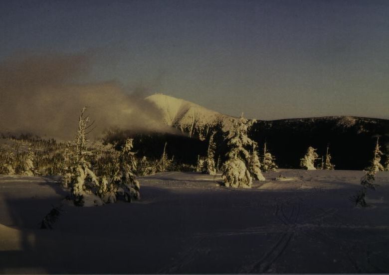
Krkonoše forms the border with Poland along the north of Bohemia and holds the country's highest terrain. The main ridge runs roughly east-west for around 35 kilometres. At the western end, Žalý (1,035 m) and Medvědín (1,235 m) provide gentler introductions to the range; eastward, the ground rises through Luční hora (1,555 m) to Sněžka (1,602 m), the dominant summit.
The principal ridgeline route — Hřebenová cesta — follows red markers the length of the main ridge and is feasible as a multi-day traverse, with overnight stops at mountain huts at Vosecká bouda, Luční bouda, and Sněžka. The upper plateau is exposed moorland, treeless above roughly 1,300 m, with vegetation protected under the Krkonoše National Park designation. Walkers must stay on marked paths in core zones.
Access is straightforward from Špindlerův Mlýn, Pec pod Sněžkou, and Vrchlabí, all connected by bus from Hradec Králové and Trutnov. A cable car from Pec pod Sněžkou reaches the Polish chapel on the Sněžka summit, though the walking approach via the red-marked path from Obří důl is the more informative route.
Key Routes in Krkonoše
- Hřebenová cesta (red): full ridgeline traverse, approx. 35 km, two to three days with hut stops.
- Obří důl to Sněžka (blue): 8 km return from Pec pod Sněžkou, significant elevation gain.
- Labský důl circuit (green): gorge walk below Labská bouda, 12 km, suitable year-round.
- Harrachov to Vosecká bouda (red): western ridge approach, 14 km, moderate.
Jeseníky — Hrubý Jeseník
The Hrubý Jeseník range in northern Moravia centres on Praděd (1,491 m), the highest point in Moravia and Silesia. The range is less visited than Krkonoše and has a noticeably different atmosphere — broader, quieter, with fewer crowds even in summer. The landscape around Praděd is designated as a Protected Landscape Area, with a National Nature Reserve on the upper slopes.
The television tower on Praděd's summit serves as a navigational landmark visible from much of the range. The red-marked approach from Ovčárna (a mountain settlement accessible by road) covers 6 kilometres with around 350 metres of ascent — straightforward in summer, icy and wind-exposed in winter. A longer approach from Karlova Studánka (11 km, red then blue markers) passes through the Bílá Opava waterfall gorge, one of the range's more scenic sections.
The Ramzovská sedlo (pass) divides Hrubý Jeseník from the lower Rychlebské hory to the north. The plateau above Ovčárna offers cross-country ski terrain in winter that converts to open meadow walking in summer, with wide views south toward Olomouc and north into Polish Silesia on clear days.
Key Routes in Jeseníky
- Karlova Studánka to Praděd (red/blue): 11 km one-way, waterfall gorge, full ascent.
- Ovčárna loop (red/yellow): 8 km circuit on the Praděd plateau, panoramic.
- Jeseník to Červenohorské sedlo (blue): 18 km ridge walk, moderate to strenuous.
Šumava — Bohemian Forest
Šumava runs along the German and Austrian border in southwestern Bohemia. Unlike Krkonoše or Jeseníky, it is primarily a plateau landscape — broad, forested, dotted with peat bogs and glacial lakes — rather than a range of peaks. Boubín (1,362 m) and Plechý (1,378 m) are the high points, but neither involves the exposed summit feel of Sněžka or Praděd.
Much of the Šumava National Park's interior is wilderness zone, closed to free access. Walkers follow a corridor of marked trails. Boardwalk sections cross the peat bogs — notably around Chalupská slať and Jezerní slať near Modrava — and are the primary access into these protected wetland habitats. The glacial lakes, Černé jezero and Čertovo jezero near Železná Ruda, are accessible on marked day routes and see heavy summer use.
The Povydří gorge along the Vydra river between Antýgl and Čeňkova Píla is one of Šumava's more dramatic lowland routes — a 13 km riverside path through granite boulders, with marked access from Srní or Modrava.
Key Routes in Šumava
- Modrava to Chalupská slať boardwalk (green): 7 km return, bog ecosystem, easy terrain.
- Železná Ruda to Černé jezero (blue): 5 km one-way, glacial lake.
- Povydří gorge (green): 13 km, riverside, granite boulders, Antýgl to Čeňkova Píla.
- Boubín primeval forest circuit (red/blue): 6 km, old-growth reserve, Zátoň access.
Beskydy — Moravian-Silesian Range
The Beskydy span the eastern tip of Moravia along the Slovak and Polish borders. Lysá hora (1,323 m) is the dominant summit. The range is well-forested — beech and spruce on the upper slopes — with a developed tourist infrastructure: mountain huts, marked circuits, and winter ski areas around Pustevny ridge, Radhošť, and Frenštát pod Radhoštěm.
The Radhošť summit (1,129 m) carries a wooden chapel and the statue of Cyril and Methodius, and is one of the more symbolically significant summits in the range. The red-marked approach from Trojanovice takes around two hours and follows broad ridge paths with views toward Lysá hora.
The Lysá hora ascent from Ostravice (14 km return, red then green markers) is the standard route and passes through open clearings before gaining the exposed summit ridge. Conditions can be surprisingly demanding above 1,200 m in winter, with icing and strong southwest winds.
Key Routes in Beskydy
- Trojanovice to Radhošť (red): 8 km return, cultural summit, moderate.
- Ostravice to Lysá hora (red/green): 14 km return, main summit route.
- Pustevny ridge circuit (yellow/blue): 12 km, ridge walking, cable car access option.
Trail conditions change with season and weather. Check current status with Horská služba ČR before setting out on exposed ridgeline routes. Information here reflects general conditions and should not replace current local advice.
Trail Marking System in Practice
The KČT colour-coded system uses rectangular paint marks: a horizontal coloured band between two white bands on fixed surfaces. Red marks indicate the principal long-distance routes; blue, green, and yellow mark secondary and connecting paths. At junctions, painted directional arrows with destination names and distances (in hours rather than kilometres) supplement the marks. Klub českých turistů publishes printed maps at 1:50,000 scale covering each mountain area, and digital maps are available through Mapy.cz, which accurately reflects the KČT trail network.
Winter conditions reduce the reliability of markers: snow can bury ground-level signs, and forest trails become harder to follow when blowdowns obscure the blazes. On open ridgelines in winter, navigation by compass and map remains important even when GPS devices are available. Battery failure in cold conditions affects electronic aids more than paper maps.
Last updated: 1 May 2026. Information based on conditions in the Czech mountain ranges as of that date.